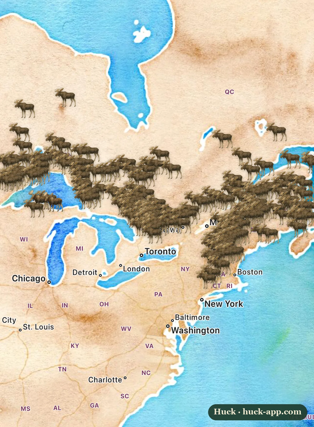
A bull moose in October is the most dangerous-looking beautiful thing in the American woods. He is in the rut, running on testosterone and almost no food, carrying forty pounds of antler, and he will walk out of a tree line at dawn like he owns it. This is the month to see one, and the map shows where to point yourself. What jumps out is not where the moose are but where they abruptly stop: a hard line across the top of the country, with almost nothing below it.
The biggest deer on Earth
A moose is a deer, which never quite computes until one is standing in the road in front of you. A big bull weighs well over a thousand pounds and stands taller at the shoulder than a saddle horse, and the antlers, broad flat palms rather than the branching rack of an elk, can span six feet across and are grown fresh every single year. Those antlers are the whole point of October. Bulls spend the rut thrashing brush, calling, and sparring for cows, and a sound you can mistake for two canoes knocking together in the dark is often two bulls settling it.
Why the map stops where it does
The moose is built for cold the way few animals are: a dark, hollow-haired coat, a body the size of a walk-in freezer that holds heat easily, and long legs made for snow. The flip side is that it overheats at temperatures that feel mild to us. By late summer a moose is already working to shed heat, and a run of warm days sends it looking for shade and water instead of food. That is why the southern boundary on the map is less a wall than a thermometer reading. Moose live where the summers stay cool and the winters stay long, and as that zone shifts, so do they.
One honest caveat about the picture: a moose is a loner, not a herd animal. The dense drifts of animals you see here are many separate sightings stacked up, not a gathered crowd. Outside of the rut a moose spends most of its life alone, which is part of why a thousand-pound animal can live an hour from a major city and almost never be seen.
The ghost moose problem
The warming edge is not an abstraction, and the clearest way to see it is a tick. The winter tick latches onto moose by the tens of thousands, as many as ninety thousand on a single calf, and a maddened, anemic animal rubs against trees until it has scraped off much of its own coat, leaving the pale, ragged look that gets these moose called ghost moose. Shorter, warmer, less snowy autumns let far more ticks survive to find a host, and in the worst New England years the ticks kill most of the calves born that spring. It is a slow-motion squeeze, run by a parasite that a cold snap used to keep in check.
Deer are bringing a brain parasite north
There is a second mechanism, and it rides in on the moose’s smaller cousin. White-tailed deer carry a roundworm called brainworm that does them no harm at all, but in a moose it reaches the brain and is almost always fatal, producing animals that walk in circles and lose their fear of people. As milder winters let white-tailed deer push farther north into moose country, they carry brainworm with them. The moose did not change; its neighborhood did, and the new neighbors came with something it cannot survive.
What happened in Minnesota
Minnesota is the cautionary tale sitting at the left edge of this map. The state’s northwestern moose population fell from several thousand animals in the 1980s to barely a hundred, a near-total collapse, and the larger northeastern herd in the Arrowhead dropped by more than half before leveling off. Biologists point to the same stack of pressures, heat stress, winter ticks, brainworm, and liver flukes, all of them loosened by warming. It is the most-studied moose decline in the country, and the reason the animals clustered thickest on the map still deserve a close watch rather than a shrug.
Where and when to see one
If you want to see a moose this fall, go north and go early. In the East that means the Moosehead Lake and Baxter State Park country in Maine, the Great North Woods around Pittsburg in New Hampshire, the Green Mountains of Vermont, and the Adirondacks in New York. Around the Great Lakes it means the Superior National Forest and the Gunflint Trail in Minnesota, and the Upper Peninsula of Michigan. Look at first and last light along bogs, beaver ponds, and willow-choked wetlands, where moose come to feed. And keep your distance, a rutting bull or a cow with a calf will charge, and a moose hurts far more people in these woods than the bears do.
This map frames the eastern and Great Lakes range, which is only part of the story. Moose also run down the northern Rockies through Montana, Wyoming, and Idaho, across the Pacific Northwest, and up through Alaska and almost all of Canada, where the biggest bodies and the biggest antlers are.
What the community data shows
This map is built from the roughly fifty thousand research-grade moose observations recorded across the Lower 48 on iNaturalist, almost all of them with open coordinates, so the shape you see is real and not an artifact of hidden pins. Community sightings always track where people go as much as where animals are, but the pattern here is unusually clean: a solid band of moose across the North Woods and a near-empty country below it, exactly the hard edge the biology predicts.
About the data
Sightings shown are research-grade community observations from iNaturalist, mapped in Huck; counts are current as of October 2026, and coordinates are open for essentially all moose records. The rut timing, the animal’s heat sensitivity, the winter-tick and brainworm pressures, and the Minnesota decline draw on state wildlife agency reporting and published moose research.