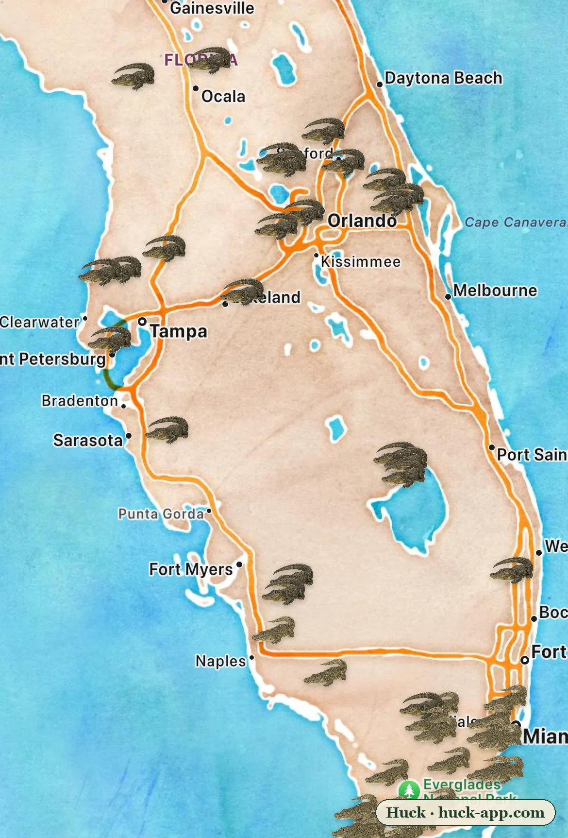
Look at where the pins fall on the map above. Alligators show up everywhere: golf course ponds outside Orlando, lakes in Gainesville, retention canals in Tampa, the whole freshwater sprawl of the peninsula. The crocodiles are doing something completely different. Nearly every one of them is packed into the bottom edge of the state, along the mangrove coast from Florida Bay up through Biscayne Bay. That crowded little corner is a genuine world exclusive: the only place on Earth where alligators and crocodiles naturally live side by side.
Two animals people constantly mix up
The confusion is understandable; the two are cousins with the same general silhouette. But they split tens of millions of years ago, and the split shows. The American alligator is a freshwater animal: broad U-shaped snout, nearly black, at home in any pond, marsh, or drainage ditch from Texas to North Carolina. The American crocodile is mostly a saltwater animal: narrower V-shaped snout, olive-gray, a shy coastal species whose real home is the Caribbean - Cuba, Jamaica, the coasts of Mexico and Central America. South Florida is the very northern edge of its world.
The reason they can share an address at all comes down to plumbing. Crocodiles carry working salt glands on their tongues, so seawater does not bother them. Alligators lack that equipment and mostly stay where the water is fresh. South Florida is where those two worlds physically touch: the freshwater Everglades drains into the salt of Florida Bay through a wide brackish seam of mangroves, and in that seam, gator country and croc country overlap.
Gators own the fresh water. Crocs own the salt. South Florida is the seam where the two worlds touch.
Two comebacks, one loud and one quiet
Neither animal was supposed to still be here in these numbers. Hide hunting nearly emptied the Southeast of alligators by the 1960s; they were on the very first endangered species lists, and their rebound was so complete that by 1987 the federal government declared them fully recovered. Today Florida alone holds well over a million, which is why the top of the map looks the way it does.
The crocodile’s comeback happened with almost nobody watching. By 1975, when the species was listed as endangered, only a few hundred remained in Florida, with just a couple dozen nesting females. Protection, plus some unlikely refuges - including the 5,000-plus acres of cooling canals at the Turkey Point power plant, where nesting crashed after the canals overheated in 2014 and recovered once the utility began adding water - let the population climb back to roughly 2,000 today, enough to be downlisted from endangered to threatened.
It would be tidy to call that a finished success story, and it is not. The federal recovery plan looks past the headline number: it calls for stable breeding populations in North Key Largo, Flamingo, and northeastern Florida Bay, reports that overall nesting has declined, and names sea-level rise as an ongoing threat to the low coastal seam the crocodiles depend on. The comeback is real, and it is also fragile - a recovery living inches above the water line.
What the community data shows
The map in this story is built from community observations on iNaturalist: about 57,000 research-grade alligator records in and around Florida against roughly 3,600 American crocodile records in the state’s south - a 16-to-1 ratio that mirrors how differently the two animals live. Alligators are everywhere people are, so they get photographed constantly. Crocodiles keep to mangrove shorelines that most people never visit.
The usual honest caveats apply. Sightings track where people look, and iNaturalist deliberately obscures the exact coordinates of crocodile records to protect a threatened species, so those pins are plotted approximately within their general area. At the scale of a whole state, the pattern holds: the crocodile cluster sits exactly where the science says the population lives, and the one place both animals appear together on the map is the one place both actually swim the same water.
One more pattern is worth watching. Year over year, a growing share of Florida’s crocodile reports come from outside the traditional core areas: about 12 percent of records in 2016, and about 23 percent by 2025, with the Flamingo core’s share of reports shrinking from three-quarters to under six in ten. Sightings measure encounters rather than population, but that spread is consistent with what wildlife officers keep confirming one stray at a time - young crocodiles turning up in canals and beaches well north of their strongholds.
If you want to tell them apart
In the overlap zone, three checks settle it. Snout: broad and rounded means alligator, narrow and tapered means crocodile. Color: gators read almost black, crocs olive to gray-tan. Teeth: with the mouth closed, a crocodile’s fourth lower tooth still shows; an alligator hides it. And one more that requires no fieldcraft at all: if you are standing in fresh water north of the Everglades, it is an alligator. The crocodiles are all at the bottom of the map.
About the data
Sightings shown are research-grade community observations from iNaturalist, mapped in Huck; counts are as of August 2026 for Florida and nearby waters. American crocodile records carry obscured coordinates (a standard iNaturalist protection for threatened taxa), so those pins are approximate; totals and the overlap pattern are unaffected. Population history draws on US Fish and Wildlife Service listing and recovery records for both species and published work on the Florida crocodile population.