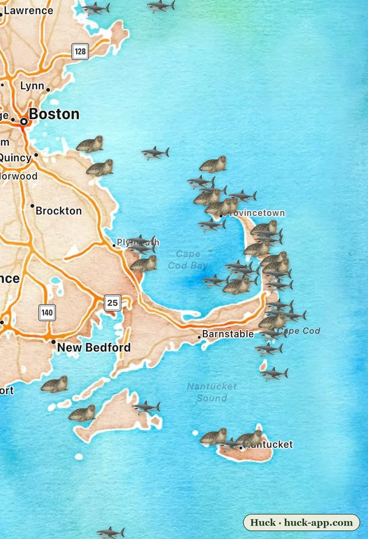
Look at the map above. The gray seals and the white sharks are not scattered around Cape Cod at random. Both species trace the same narrow line: down the Atlantic-facing beaches from Provincetown past Chatham to the Monomoy sands, then out to Nantucket. Cape Cod Bay is quieter. Nantucket Sound is quieter still. Two very different animals, one shared line on the map - because one of these maps is causing the other.
The ocean off New England used to be emptier
A century ago you could walk the outer beaches of Cape Cod all summer and never see a seal. That was policy, not nature. Massachusetts and Maine paid a bounty for dead seals for decades - fishermen saw them as competition - and by the time the bounties ended, gray seals had been all but eliminated from US waters. The big predator that followed them had no reason to visit an empty pantry.
The turn came in 1972, when the Marine Mammal Protection Act made it illegal to kill or harass seals in US waters. Nothing dramatic happened at first. Recovery started as a trickle of animals moving down from Canada, and in the late 1980s biologists documented a handful of gray seal pups on Muskeget Island, west of Nantucket - among the first born in Massachusetts in generations.
Then the trickle became a flood. Today the gray seal population in southeastern Massachusetts is estimated in the tens of thousands, with the biggest haul-outs on Monomoy and Muskeget - the exact places where the seal pins stack up on the map.
The sharks were never after us
White sharks were seen off New England all along, but only occasionally - passing through, mostly offshore, mostly ignored. That changed within a few decades of the seal comeback. By 2009, researchers were tagging white sharks right off Chatham, and in the years since, hundreds of individual white sharks have been identified in these waters. Cape Cod is now one of the largest known seasonal gatherings of white sharks in the world.
The reason is on the map. A gray seal is a 500-plus-pound package of calories, and tens of thousands of them now line the outer beaches. The sharks patrol that shoreline - often in water shallow enough for a person to stand in - because that is where seals enter and leave the water. The shark map does not show where sharks like to swim in some abstract sense. It shows where the seals are.
The shark map does not show where sharks live. It shows where the seals are.
What the community data shows
The map in this story is built from research-grade community observations on iNaturalist: 43 white shark records and 1,924 gray seal records in the waters around Cape Cod at the time of writing. That ratio - roughly 45 seal sightings for every shark sighting - is itself the story. The prey is everywhere and easy to photograph from the beach. The predator is rare, mostly submerged, and seen only when it surfaces near a boat or a swim line. But when a white shark is recorded, it is recorded on the outer beaches, along the seal line.
It is worth being precise about what community-science pins can and cannot say. They reflect where people looked as much as where animals are: the outer Cape gets photographed constantly in summer, and much of the shark activity happens where no one is watching. Researchers using tags and spotter planes see far more sharks than beachgoers ever will. But the pattern in the community data matches what those researchers report - shark activity concentrated along the Atlantic-facing beaches, peaking from August through October.
Living with a wilder ocean
In 2018, a young bodyboarder named Arthur Medici was killed by a white shark at Newcomb Hollow Beach in Wellfleet - the first shark-attack death in Massachusetts in over eighty years. It was a tragedy, and it is part of this story too. A recovered ocean is not a petting zoo. The same protections that refilled the beaches with seals brought back the animal that eats them.
The practical advice for Cape Cod swimmers is simple and worth taking seriously in late summer: swim at lifeguarded beaches, stay close to shore, avoid swimming near seals, and heed the purple shark flags. The sharks are not looking for people. Eighty years of evidence says they are looking for exactly what the map shows: seals.
Fifty years ago, this map would have been blank - no seals, no sharks, an ocean quieter and poorer than the one that was here before us. The crowded, complicated map we have now is what recovery actually looks like.
About the data
Sightings shown are research-grade community observations from iNaturalist, mapped in Huck. White shark locations on iNaturalist are publicly visible at full precision; counts are as of August 2026 for the waters bounded by Cape Ann, Nantucket, and Buzzards Bay. Population history draws on NOAA Fisheries stock assessments and published survey work on gray seal recolonization and white shark tagging in New England.